Federal Projects
U.S. Department of Agriculture (USDA), Economic Research Service
Economic Research on the Joint Contribution of the Supplemental Nutrition Assistance Program (SNAP) and Unemployment Insurance (UI) to the Nation’s Safety Net
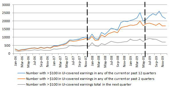
Data Source: JFI calculations based on administrative records received from the Maryland Department of Human Services (DHS).
JFI is the lead partner of a five state consortium (Georgia, Illinois, Maryland, Michigan and Texas) analyzing the interaction of SNAP caseload and recipient household composition dynamics aligned with receipt of UI benefits and participation in UI covered employment. Using linked state administrative records for SNAP, UI wage records and UI benefits, the alignment in time between individuals’ receipt of UI benefits and SNAP benefits is examined, including how much overlap occurs in the receipt of benefits and how long do households receive UI benefits before receiving SNAP benefits.
Interactive Map of Community Managed Open Spaces
In 2013, the Baltimore Neighborhood Indicators Alliance (BNIA-JFI) piloted a publicly- accessible, interactive map for this purpose using the pattern community-managed open space. Now, in 2014, BNIA-JFI is enhancing the map features and adding a second element for stormwater management. Future iterations of the map will include components of the remaining six green patterns.This mapping project was funded through an agreement with the U.S. Department of Agriculture, U.S. Forest Service, Northern Research Station.