Search Results for: Baltimore Neighborhood indicators

Baltimore Neighborhood Indicators Alliance

BNIA - Baltimore Neighborhood Indicators Alliance

The goal and mission of the Baltimore Neighborhood Indicators Alliance – Jacob France Institute (BNIA-JFI) of the University of Baltimore is to provide accurate data and objective research to a wide range of groups, organizations, and agencies that result in positive policy change. BNIA-JFI strengthens the principle and practice of well-informed decision making to support stronger neighborhoods, an improved quality of life, and a thriving city. This is accomplished through providing accurate, reliable, and accessible and actionable data, indicators, and research that describe the social economic and quality of life issues impacting the City and its neighborhoods.

For more information about this program visit the BNIA website at www.bniajfi.org or contact bnia-jfi [at] ubalt [dot] edu at (410) 837-4377.

.


Vital Signs

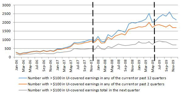
Vital Signs are groups of related data points compiled from a variety of reliable sources that “take the pulse” of Baltimore’s neighborhoods. Each Vital Sign comprises a set of data which, taken together, form a picture of any given neighborhood’s quality of life and overall health.

The Vital Signs help BNIA, community members, decision makers, and funders to measure progress towards meaningful, positive outcomes at the community level, and measure needs in specific and actionable ways.

Vital Signs data include more than 150 indicators related to demographics, housing, crime, workforce, health, housing, education, and sustainability. These indicators can be compared to one another, on a community-by-community basis, or to the whole of Baltimore City.

The data is an open source and available for others to use for their integral needs. Whether it is personal projects, mapping tools, software, student projects, individual and organizational research, articles and blog posts, BNIA has you covered. Community members and leaders may find it most useful to examine their community’s data in context to the city or adjacent communities to assess the areas of most need and progress


Baltimore Community Change 2010-2020 Project

The Baltimore Neighborhood Indicators Alliance has prepared a series of reports to reflect on the changes that have occurred in Baltimore’s neighborhoods over the past decade. We have begun to work with the preliminary Decennial Census release from August 2021, and unfortunately, the results are discouraging so far. Overall, Baltimore City experienced -5.7% population loss between 2010 and 2020 according to the latest data release. Our current population is 585,708 which is the lowest population in a century. But as with almost everything, population does not affect every part of the city in the same way. Downtown/Seton Hill grew by 46.6% in the last decade and has nearly doubled its population since 2000. Just minutes away from downtown, however, Sandtown-Winchester/Harlem Park lost -29.3% of its population in the same decade. To help us all understand why this might have occurred and how to turn these trends around, we are creating a series of briefs to assess the population and socio-demographics, housing diversity, occupancy, accessibility, connectivity, and quality of life of Baltimore’s neighborhoods and analyze how they have changed.


Baltimore Data Day

Baltimore Data Day logo

Baltimore Data Day is an annual workshop to help communities expand their capacity to use technology and data to advance their goals. Since 2010, community leaders, nonprofit organizations, governmental entities and civic-minded “hackers” have come together to see the latest trends in community-based data, technology and tools and learn how other groups are using data to support and advance constructive change. Baltimore Data Day is structured around a series of “how to” interactive workshops in which people who work with data will explain what data is available, how to access data, and why data can be actionable for communities.


Project VITAL: Vacant Lot Improvement to Transform Adolescent Lives

People living near vacant lots and abandoned buildings exhibit poor health; fortunately, recent research has shown that when vacant lots are greened and restored, the health of residents greatly improves. To date, most of this research has focused on adults. BNIA-JFI is part of a collaborative inter-university team to expand on this body of evidence to determine whether and how restoring vacant lots can mitigate health inequalities among disadvantaged adolescents, whose health and well-being are strongly influenced by neighborhood factors. BNIA-JFI’s main role in the project is to build a sharable database containing key characteristics of restored and unrestored vacant lots; While Baltimore City currently has over 18,000 vacant lots and 17,000 abandoned buildings, the City has developed a plan to ‘clean and green’ vacant lots in neighborhoods with large concentrations of vacancy. This provides us with a timely opportunity to explore the impact of vacant lot restoration on the health of adolescents living in disadvantaged neighborhoods, with findings that can be used to develop long-term strategies for improving adolescent health equity.


‘The Pipeline’ tracks development projects in the pre-planning stages as a service to developers. Understanding and keeping track of the status of projects during the development review phase is complicated because projects evolve as developers ensure compliance with local land use regulations and produce contextually sensitive final designs. The purpose of the ‘The Pipeline’ is to develop a database and visualization prototype that tracks development projects through the review process and documents the status of the project prior to obtaining a building permit. The database of projects is geocoded and available for visualization on an online mapping tool http://realestate.bniajfi.org.  Other data sources include real estate news outlets and other local information. The partnership has sponsored students from the Merrick School of Business Real Estate program to serve as research assistants.


GEOLOOM is rooted in the idea that arts and culture play a significant role in fostering the vitality of a place. Neighborhood-based arts and cultural activity can have an impact on residents’ attachment to their community, the overall economic conditions in their neighborhood, and the quality of life for the entire city.

GEOLOOM provides better understanding of the arts and culture landscape along with the ability to view data within a broader context of demographic, real estate, and ecological information. It will help all of us in decision-making about the City’s future. Through visualization, GEOLOOM will aid cultural institutions, businesses, and elected officials by heightening their awareness of potential audiences, customers, and constituents.

The data you will find in GEOLOOM will be analyzed every year so we can successfully measure community improvements over time, identify gaps and, confidently address arts and culture needs while strengthening all aspects of the City’s social and economic fabric. We welcome feedback on the data and continuously seek to expand both the definition of arts and culture and the types of data available on the website.

GEOLOOM will help you find just what you need – in your neighborhood or across town. The GEOLOOM co>map: community, collaboration, and cohesion in Baltimore.

A Win for a More Equitable Baltimore

To The University of Baltimore Community:

We all are aware of the cost of segregation in our lives. But too often, we’re not sure how to measure its impact, and, in turn, how to begin to change it for the better.

Our own Baltimore Neighborhood Indicators Alliance, part of the Jacob France Institute in the Merrick School of Business, will work with the Maryland Center on Economic Policy (MDCEP) to document links between local housing choice voucher policies and segregated housing patterns.

As part of a grant soon to be announced by The Urban Institute, this project will consider whether a better way could be found for Baltimore to hold down rental inflation, keep housing affordable for all, and provide more living choices for families that use vouchers.

The city’s segregation problem worsened after the 2008 housing crisis, according to MDCEP, “particularly with the growing concentration of households with a housing choice voucher in neighborhoods where homeowners moved to the rental market during the Great Recession.”

Now, thanks to UBalt’s own expertise in understanding complex issues such as this one, we can begin to work on solutions to the barriers that stand in the way of a stronger, more equitable Baltimore.

Congratulations to BNIA-JFI and MDCEP for their efforts. Once again, the University is right in there, doing the work and supporting positive change.

Have a wonderful rest of the week.

Kurt L. Schmoke
President

Federal Projects

U.S. Department of Agriculture (USDA), Economic Research Service

Economic Research on the Joint Contribution of the Supplemental Nutrition Assistance Program (SNAP) and Unemployment Insurance (UI) to the Nation’s Safety Net

dhr-graph

New SNAP Recipients with Earnings, 2006-2009
Data Source: JFI calculations based on administrative records received from the Maryland Department of Human Services (DHS).

JFI is the lead partner of a five state consortium (Georgia, Illinois, Maryland, Michigan and Texas) analyzing the interaction of SNAP caseload and recipient household composition dynamics aligned with receipt of UI benefits and participation in UI covered employment. Using linked state administrative records for SNAP, UI wage records and UI benefits, the alignment in time between individuals’ receipt of UI benefits and SNAP benefits is examined, including how much overlap occurs in the receipt of benefits and how long do households receive UI benefits before receiving SNAP benefits.


Interactive Map of Community Managed Open Spaces

In 2013, the Baltimore Neighborhood Indicators Alliance (BNIA-JFI) piloted a publicly- accessible, interactive map for this purpose using the pattern community-managed open space. Now, in 2014, BNIA-JFI is enhancing the map features and adding a second element for stormwater management. Future iterations of the map will include components of the remaining six green patterns.This mapping project was funded through an agreement with the U.S. Department of Agriculture, U.S. Forest Service, Northern Research Station.

David Epstein, Ph.D.

David Epstein

Research Associate

David Epstein, Ph.D. examines the ties between decision-making and information access, especially in regard to interventions made by public agencies, community based organizations and philanthropy in distressed urban areas. Dr. Epstein’s methodological approach combines quantitative, spatial and qualitative methods. His prior research focuses on a neighborhood indicators system in Cleveland and provides a generalizable framework for identifying situations in which parcel-based data systems help community development corporations rehabilitate vacant and abandoned housing. Dr. Epstein was a Fulbright Fellow in Israel (2006) where his work revealed the sharp tensions between environmental conservation and economic development in a Galilean valley. From 1999 to 2004, Dr. Epstein worked for the labor union, UNITE, both as an organizer and as a strategist. He holds a Master’s Degree in Urban Planning and a Ph.D. in Urban and Regional Planning from the University of Michigan.


Current Projects

Stacey M. Lee, PMP

Program Manager

Ms. Lee has been with JFI since 1997. She provides the Institute with project management, web management, administration, procurement, marketing and IT support.

Current grant sponsored projects include project management for:

  • The Maryland Department of Human Services Family Investment Administration,
  • The Governor’s Office of Crime Control and Prevention website, and
  • Baltimore City Department of Social Services Family Investment Administration and Foster Care.

Stacey is a certified PMP from the Project Management Institute. She received her Masters degree in Project Management from UMUC in 2010, and her bachelors degree from the University of Baltimore.

Projects

Stacey Lee & UB Bee 91814

  • Department of Human Services Family Investment Administration (DHS)
  • Evaluation of Job Skills Enhancement Pilot Program
    Project Manager:
    As project manager, Stacey is responsible for coordinating with several JFI staff members to ensure that the following list of deliverables are submitted on time.

    • Quarterly submission of TANF Performance Measurers
    • Report – Analysis of SNAP Caseload and Recipient Household Composition Dynamics Aligned with Receipt of UI Benefits and Participation in UI Covered Employment
    • Report – Analysis of Employment Opportunities for TCA Recipients in High Growth Industries in Maryland
    • Ad hoc reports for the Hiring Division of DHS
    • Consultant Services
  • Baltimore City Department of Social Services – BCDSS
  • Family Investment Administration
    Project Manager:
    Ms. Lee, along with several other JFI staff members provides project and performance management assistance to the Family Investment Bureau, Baltimore City Department of Social Services. FIB provides various forms of assistance to low-income individuals while preparing them to become financially independent. These include Temporary Cash Assistance, Food Stamps, Medical Assistance, and the Temporary Disability Assistance Program.Stacey monitors the technical assistance provided on the development and delivery of a new verification system developed by David Carpenter, SQL Database Programmer at JFI to help streamline the application process of new claims. She also provides technical assistance and support to the data analyst located at BCDSS, who is responsible for producing the monthly Citi-Stat reports.
  • Baltimore City Department of Social Services – BCDSS
  • Foster Care – Independent Verification Agent
    Project Manager:
    Stacey Lee provides technical assistance, project management and other administrative support related to the work of the Independent Verification Agent (IVA), Rhonda Lipkin, LLC. The Independent Verifying Agent (IVA) was appointed by the District Court of Maryland under Consent Decree in the matter of L.J., eta al v. Massinga. Et al. (the “Decree”) by order dated August 23, 2011. The Decree states that BCDSS must meet specific performance measures and associated targets. BCDSS is required to report to the court on performance of these measures on regular intervals. An accurate, valid and reliable report regarding Internal Success Measurers and Exit Standards shall be submitted twice a year and will be independently verified by the IVA.
  • Governor’s Office of Crime Control and Prevention – GOCCP
    Project Manager
    Ms. Lee is responsible for contract renewals, invoicing, and technical support to the web development and maintenance of the Governor’s Office of Crime Control and Prevention. She works with Tao Weilundemo, Web Developer for JFI.

09_job_opptys_rpt.pdf”>Mid-State Differences in Job Opportunities for Maryland Welfare Recipients
Jane Staveley and David Stevens
June 2009


2008 Publications


2007 Publications


2006 Publications


2005 Publications


2004 Publications


2003 Publications


2002 Publications


2001 Publications


2000 Publications


1999 Publications


To order copies of these reports please contact Jacob France Institute (410) 837-4727 or email:smlee [at] ubalt [dot] edu.

Download Adobe Acrobat

Cheryl Knott

Research Manager / Interim Director, Baltimore Neighborhood Indicators Alliance

Cheryl Knott is the Research Manager and Interim Director for the Baltimore Neighborhood Indicators Alliance-Jacob France Institute. Since 2007, Cheryl has worked to ensure the accuracy, consistency, and reliability of community indicators that describe the quality of life for Baltimore City communities. She coordinates with staff and external data-creating agencies to produce customized statistical and research reports and evaluations that examine neighborhood-level trends on socio-economic characteristics, crime and safety, public health, housing and community development, educational achievement, and sustainability.

Cheryl also provides training to the public on using data resources, community asset mapping, evidence-based practices, and communicating data for grant writing. Cheryl is involved in coordinating Baltimore Data Day, an annual event that brings together a diverse audience to talk about data and resources in the city. She is a proponent of data democratization and has a strong interest in making data open and usable to the public as well as other professionals.

Prior to her arrival at BNIA-JFI in 2007, Cheryl studied at the University of Maryland, Baltimore County (UMBC), receiving her Bachelor’s degree in Geography and Environmental Systems and a certification in Cartography in 2007 and a Master’s degree in Applied Sociology in 2013. She received a graduate certificate in Organizational Leadership from the University of Baltimore in 2022. Her research interests include the relationship between crime and the built environment, including developing new quantitative measures for studying urban crime risk at the block level.

In 2017 Cheryl was awarded the University of Baltimore Staff Award for Extraordinary Public Service to the University and Greater Community for her work on communicating data and information. She recently served two terms as the Data and Resources Subcommittee Chair for the Maryland State Geographic Information Committee (MSGIC) and is currently appointed to the Maryland Council on Open Data. In her spare time, Cheryl is a co-organizer for MaptimeBmore.

Projects

Additional project details can be found at All Research – BNIA-JFI.

Reports and Publications

Conference Presentations

  • “Building Community Indicators for Improving Baltimore’s Neighborhoods”; TUgis: Maryland’s Geospatial Conference; Towson, MD; August 2018.
  • “Working with University Students”; National Neighborhood Indicators Partnership Meeting; Indianapolis, IN; October 2017.
  • “The Ins and Outs of Data for Community-Based Indicators”; ESRI Mid-Atlantic Users Group Conference; Rockville, MD; April 2017.
  • “McElderry Park Data Viewer”; TUgis: Maryland’s Geospatial Conference; Towson, MD; March 2017.
  • “McElderry Park, Baltimore: Community-Led Strategies for Crime Reduction”; Association for Community Health Improvement Annual Conference; Baltimore, MD; March 2016.
  • “A Re-Examination of Population Inputs for Neighborhood Indicators with Applications for Crime Reporting”; American Sociological Association Annual Meeting; San Francisco, CA; August 2014.

Community-Based Trainings

  • “Using Community Indicators to Improve Baltimore’s Neighborhoods”; Neighborhood Institute; April 2018.
  • “Using Indicators to Improve Your Community”; Enoch Pratt Free Library; October 2017.
  • “Accessing Open Data: Baltimore Neighborhood Indicators Alliance”; Baltimore Data Day; July 2012-2017 (annual event).
  • “Data for Non-Profits: Baltimore Neighborhood Indicators Alliance”; Baltimore Innovation Week; October 2015.

In The News

2021

2020

2019

2018

2017

2016

2015


2014


2013


2012


2011

Publications

The following is a list of selected publications authored or co-authored by The Jacob France Institute.

2023 Publications

2022 Publications

2020 Publications

2019 Publications


2018 Publications


2017 Publications


2016 Publications


2015 Publications


2014 Publications


2013 Publications


2012 Publications


2011 Publications


2010 Publications


JFI 2009 Summer Research Papers


2009 Publications

Vital Signs 6 & 7


2008 Publications


2007 Publications


2006 Publications


2005 Publications


2004 Publications


2003 Publications


2002 Publications


2001 Publications


2000 Publications


1999 Publications


To order copies of these reports please contact Jacob France Institute (410) 837-4727 or email:smlee [at] ubalt [dot] edu.

Download Adobe Acrobat

Resources

Resource Links


City of Baltimore Resources


State of Maryland Resources


Federal Resources


Education Links


Other


1 2